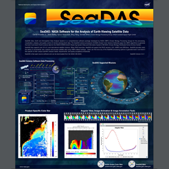
SeaDAS (Sea, Earth and Atmosphere Data Analysis System) is a comprehensive software package developed by NASA OBPG (Ocean Biology Processing Group) for the processing, visualization, analysis, and quality control of remote-sensing Earth data.

SeaDAS is a comprehensive software package developed by NASA OBPG (Ocean Biology Processing Group) for the processing, display, analysis, and quality control of remote-sensing Earth data. SeaDAS is open-source and serves as the official distribution point of the NASA OBPG Science Software.

SeaDAS is a comprehensive software package developed by NASA OBPG (Ocean Biology Processing Group) for the processing, display, analysis, and quality control of remote-sensing Earth data. SeaDAS is open-source and serves as the official distribution point of the NASA OBPG Science Software.

SeaDAS is visualization, processing, and analysis software for use with Earth-viewing satellite data. This open-source NASA software, (current version 7.4), enables users to work with all levels of OB.DAAC (Ocean Biology Distributed Active Archive Center) data. This is the official distribution source of the NASA OCSSW (Ocean Color Science SoftWare) processors (such as l2gen, l2bin, l3mapgen, etc.).

True Color Composite
This poster displays a multi‐satellite true color selective composite image generated using SeaDAS, NASA’s ocean color satellite data image visualiza1on and analysis software. A clear cloud free moment, just as the blizzard has ended on Sunday January 24 2016, reveals the extent and clear boundary of the footprint of snow left behind on the Mid‐Atlan1c and Northeast region of the United States.

Standard OBPG Products
This poster displays a multi‐satellite true color selective composite image generated using SeaDAS taken by the MODIS Aqua 10 instrument in October 2010.

Field Measurements
Measurements of HPLC derived chlorophyll a (Chlor_a) from the CliVEC CV5 cruise were used with MODIS Aqua (MODISA) Chlor_a. SeaBASS field measurement files can be directly loaded into SeaDAS. This enables a visual display of the ship’s geographical journey across a satellite derived image, as well as a correlation analysis between any relevant satellite products and their respective field measurements.

(International Ocean Colour Science)
This poster illustrates some of the capabilities of SeaDAS for ocean color satellite data image visualization and analysis. Though specific in nature, the approaches, images and results presented here contain concepts which are readily adaptable by the user to their own specific applications.
