
The OCSSW Cookbook
Binning & Mapping
SST mapped image (VIIRS)
|
This set of examples uses l2bin and l3mapgen to create SST mapped images from source VIIRS level-2 files.
Each example illustrates a different masking level.
|
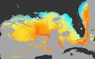
Example 1: Best Quality
qual_max=0
flaguse=LAND,HISOLZEN
|
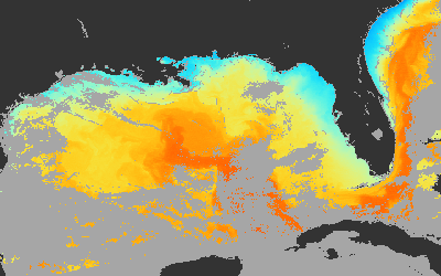
Example 2: Science Quality
qual_max=2
flaguse=LAND,HISOLZEN
|
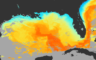
Example 3: Imagery Quality (Higher Retrievals - DAY only)
qual_max=3
flaguse=ATMFAIL,LAND,HISATZEN,CLDICE,NAVWARN,
MAXAERITER,ATMWARN,HISOLZEN,NAVFAIL,HIGLINT
|
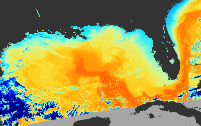
Example 4: No Quality Restrictions
qual_max=3
flaguse=LAND,HISOLZEN
|
Example 1 Best Quality
Applies the highest degree of sst quality masking for best quality results (though lowest pixel retrieval count).
Command Line Entry
l2bin ifile=V2015045190600.L2_SNPP_SST.nc ofile=V2015045190600.L3b_SST_BestQual_1km.nc par=l2bin_SST_BestQual.par
|
l3mapgen ifile=V2015045190600.L3b_SST_BestQual_1km.nc ofile=V2015045190600.L3m_SST_BestQual_750m.nc par=l3mapgen.par
|
File = l2bin_SST_BestQual.par
prodtype=regional
resolution=1
qual_prod=qual_sst
qual_max=0
l3bprod=sst
flaguse=LAND,HISOLZEN
|
File = l3mapgen.par
product=sst
resolution=750
interp=area
oformat=netCDF4
|
Example 2 Science Quality
This is the standard masking level used for science quality results. There will be some
blockiness of missing data caused by straylight and non-uniformity algorithms.
Command Line Entry
l2bin ifile=V2015045190600.L2_SNPP_SST.nc ofile=V2015045190600.L3b_SST_StdQual_1km.nc par=l2bin_SST_StdQual.par
|
l3mapgen ifile=V2015045190600.L3b_SST_StdQual_1km.nc ofile=V2015045190600.L3m_SST_StdQual_750m.nc par=l3mapgen.par
|
File = l2bin_SST_StdQual.par
prodtype=regional
resolution=1
qual_prod=qual_sst
qual_max=2
l3bprod=sst
flaguse=LAND,HISOLZEN
|
File = l3mapgen.par
product=sst
resolution=750
interp=area
oformat=netCDF4
|
Example 3 Imagery Quality (Higher Retrievals - DAY only)
This illustrates an approach for producing imagery with more sst pixels retrieved than when using the standard
quality, and without all the blockiness of missing data caused by straylight and non-uniformity algorithms.
This can only be done on daytime sst file because it uses many level2 flags which are only available from visible
band daytime measurements.
Note: The naming "Imagery Quality" is not official, but just used here for illustrative purposes related to this
set of cookbook examples.
Command Line Entry
l2bin ifile=V2015045190600.L2_SNPP_SST.nc ofile=V2015045190600.L3b_SST_AvgQual_1km.nc par=l2bin_SST_AvgQual.par
|
l3mapgen ifile=V2015045190600.L3b_SST_AvgQual_1km.nc ofile=V2015045190600.L3m_SST_AvgQual_750m.nc par=l3mapgen.par
|
File = l2bin_SST_AvgQual.par
prodtype=regional
resolution=1
qual_prod=qual_sst
qual_max=3
l3bprod=sst
flaguse=ATMFAIL,LAND,HISATZEN,CLDICE,NAVWARN,MAXAERITER,ATMWARN,HISOLZEN,NAVFAIL,HIGLINT
|
File = l3mapgen.par
product=sst
resolution=750
interp=area
oformat=netCDF4
|
Example 4 No Quality Restrictions
This is the lowest possible level of masking without including "really, really bad" data. You can expect clouds,
ice and just about anything present to return a sst value, which may or may not have any valid temperature meaning.
Command Line Entry
l2bin ifile=V2015045190600.L2_SNPP_SST.nc ofile=V2015045190600.L3b_SST_PoorQual_1km.nc par=l2bin_SST_PoorQual.par
|
l3mapgen ifile=V2015045190600.L3b_SST_PoorQual_1km.nc ofile=V2015045190600.L3m_SST_PoorQual_750m.nc par=l3mapgen.par
|
File = l2bin_SST_PoorQual.par
prodtype=regional
resolution=1
qual_prod=qual_sst
qual_max=3
l3bprod=sst
flaguse=LAND,HISOLZEN
|
File = l3mapgen.par
product=sst
resolution=750
interp=area
oformat=netCDF4
|
NOTES
Resolution: With a goal of producing a 750m resolution mapped SST file, these examples bin at 1km resolution and then map at 750m resolution.
l2bin: In general you want to pick a bin resolution lower than the source resolution. This is because each source pixel gets
put into precisely one bin. Consequently, having your bin resolution higher than your source resolution will likely result in a peppering
of missing data. Alse, keep in mind that satellite specifications refer to nadir resolution so likely many of your source pixels
are actually of a lower resolution than the nadir specification value.
l3mapgen: The mapping process differs from the strict rules of the binning process. When mapping, you
can increase the resolution of the mapped image through an area interpolation process.
Defaults: Fields in some of these par files such as 'flaguse', and 'qual_prod' are being explicitly set with their default value
so you are aware of the actual setting being used. You could also just not include these particular fields and they will get
set with the default from the configurations your particular ocssw mission config directory.