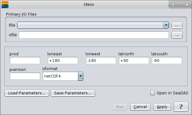
l3bin
Creates a Level 3 bin file from one or more input Level 3 bin files.
Location
SeaDAS-Toolobox -> SeaDAS Processors -> l3bin
GUI Usage
Command Line Usage
GUI Usage
Arguments/Keywords
| UI Element Name |
Type |
Description |
Required/Optional |
Default Value |
| ifile |
ifile |
listfile of input binfiles |
Required |
|
| ofile |
ofile |
output bin filename |
Required |
|
| prod |
string |
data products list |
Optional |
|
| loneast |
float |
Easternmost longitude |
Optional |
+180 |
| lonwest |
float |
Westernmost longitude |
Optional |
-180 |
| latnorth |
float |
Northernmost latitude |
Optional |
+90 |
| latsouth |
float |
Southernmost latitude |
Optional |
-90 |
| pversion |
string |
processing version |
Optional |
unspecified |
| oformat |
string |
defines output format:
    hdf4:    output a HDF4 file
    netCDF4: output a netCDF4 file
    hdf5:    output a HDF5 file
| Optional |
netcdf4 |
Actions/Buttons
| UI Element Name |
Type |
Description |
| Browser Button |
Button |
Selects ifile/ofile
|
| Load Parameters ... |
Button |
Reads in previously saved parameters and populates the fields in
GUI.
|
| Store Parameters ... |
Button |
Saves the current arguments in GUI in a file.
|
| Run |
Button |
Executes the l3bin command with arguments provided in the UI.
|
| Cancel |
Button |
Closes current processor GUI.
|
| Apply |
Button |
Makes current arguments effective.
|
| Open in SeaDAS |
Checkbox |
If selected, the ofile will be added to the open products list right after its generation.
|
| ? |
Button |
Displays the help content of the current command.
|
Command Line Usage
L3BIN 5.14 (Nov 14 2024 12:14:14)
5.14
l3bin ifile=input-file ofile=output-file prod=prodlist

  The input file is a list of L3 binned files.
  The argument-list is a set of keyword=value pairs. The arguments can
  be specified on the commandline, or put into a parameter file, or the
  two methods can be used together, with commandline over-riding.

  return value: 0=OK, 1=error, 110=no pixels binned.

The list of valid keywords follows:

   help (boolean) (alias=h) (default=false) = print usage information
   version (boolean) (default=false) = print the version
        information
   verbose (boolean) (default=off) = Allow more verbose screen messages
   dump_options (boolean) (default=false) = print
        information about each option
   dump_options_paramfile (ofile) = print
        information about each option to paramfile
   dump_options_xmlfile (ofile) = print
        information about each option to XML file
   par (ifile) (alias=parfile) = input parameter file
   pversion (string) (default=unspecified) = production version
   ifile (ifile) (alias=in,infile) = input file name with list of L3 files
   ofile (ofile) (alias=out) (default=output) = output bin file name
   oformat (string) (default=netCDF4) = output file format
           hdf4:    output a HDF4 file
           netCDF4: output a netCDF4 file
           hdf5:    output a HDF5 file

   merged (ofile) = merged file name
   latnorth (float) (default=+90) = northern most latitude
   latsouth (float) (default=-90) = southern most latitude
   loneast (float) (default=+180) = eastern most longitude
   lonwest (float) (default=-180) = western most longitude
   sday (int) (default=1970001) = start datadate (YYYYDDD)
   eday (int) (default=2038018) = end datadate (YYYYDDD)
   deflate (int) (default=5) = deflate level
   orbit1 (int) (default=-1) = sorbit
   orbit2 (int) (default=-1) = eorbit
   median (int) (default=0) = median
   noext (boolean) (default=off) = set to 1 to suppress generation of
        external files
   unit_wgt (int) (default=0) = unit_wgt
   composite_scheme (string) = composite scheme (min/max)
   composite_prod (string) = composite product fieldname
   reduce_fac (int) (default=1) = scale reduction factor (power of 2)
   resolve (string) = bin resolution, overrides reduce_frac if defined
         H: 0.5km
         Q: 250m
        HQ: 100m
        HH: 50m
         1: 1.1km
         2: 2.3km
         4: 4.6km
         9: 9.2km
        18: 18.5km
        36: 36km
        1D: 1 degree
        HD: 0.5 degree
        QD: 0.25 degree
   prod (string) (alias=out_parm) (default=DEFAULT) = bin products
        [default=all products in L3 file]

   doi (string) = Digital Object Identifier (DOI) string


