
| mapgen | |
Creates a mapped output.
Takes a product (or products if netCDF output) from an L1, L2 or L3 bin file, reprojects the data using Proj.4 and writes a mapped file in the requested output format.
SeaDAS-OCSSW -> mapgen
 |
| UI Element Name | Type | Description | Required/Optional | Default Value |
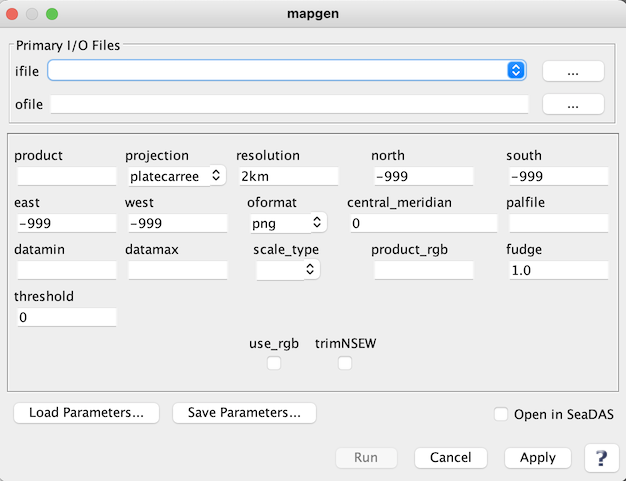
| ifile | ifile | input file or text file list of files. | Required | |
| ofile | ofile | output file name; default: <ifile>.MAP.<oformat ext>. | Required | |
| product | string | product(s) to map; comma separated | Required | |
| projection | string | One of the following predefined (proj4) projections may be selected:
        platecarree: Plate Carree (cylindrical) projection
                   projection="+proj=eqc +lat_0=<central_meridian>"
        mollweide: Mollweide projection
                   projection="+proj=moll +lat_0=<central_meridian>"
        lambert:   Lambert conformal conic projection
                   projection="+proj=lcc +lat_0=<central_meridian>"
        albersconic: Albers Equal Area Conic projection
                   projection="+proj=aea +lat_0=<central_meridian>"
        mercator:  Mercator cylindrical map projection
                   projection="+proj=merc +lat_0=<central_meridian>"
        ease2:     Ease Grid 2 projection
                   projection="+proj=cea +lon_0=0 +lat_ts=30 +ellps=WGS84
                              +datum=WGS84 +units=m +lat_0=<central_meridian>"
|
Optional | platecarree |
| resolution | string | size of the output pixel in meters or SMI dimensions:
         #.#:  width of a pixel in meters
         #.#km:  width of a pixel in kilometers
         #.#deg:  width of a pixel in degrees
|
Optional | 2km |
| north | float | Northern most Latitude | Optional | -999 |
| south | float | Southern most Latitude | Optional | -999 |
| east | float | Eastern most Longitude | Optional | -999 |
| west | float | Western most Longitude | Optional | -999 |
| oformat | string | format of the output file :
        netCDF:  Network Common Data Form v4 file
                  can contain more than one product
        png:     Portable Network Graphics format image
        ppm:     Portable PixMap format image
        tiff:    Tagged Image File Format with georeference tags
|
Optional | netCDF4 |
| central_meridian | float | central meridian to use for projection in degrees east. | Optional | 0 |
| palfile | ifile | palette file name | Optional | see $OCDATAROOT/common/product.xml |
| datamin | float | minimum value for data scaling | Optional | default from product.xml |
| datamax | float | maximum value for data scaling | Optional | default from product.xml |
| scale_type | string | data scaling type:
        linear:   linear scaling
        log:      logarithmic scaling
        arctan:   arc tangent scaling
|
Optional | default from product.xml |
| Product_rgb | string | comma separated string of RGB products e.g., product_rgb=rhos_645,rhos_555,rhos_469. | Optional | sensor specific, see $OCDATAROOT/<sensor>/l1mapgen_defaults.par |
| fudge | float | fudge factor used to modify size of L3 pixels | Optional | 1.0 |
| threshold | float | minimum percentage of filled pixels before an image is generated | Optional | 0 |
| UI Element Name | Type | Description |
| Browser Button | Button | Selects ifile/ofile |
| use_rgb | Check Box | Generate an RGB image output |
| trimNSEW | Check Box | Do not trim output to match input NSEW range |
| Load Parameters ... | Button | Reads in previously saved parameters and populates the fields in GUI. |
| Save Parameters ... | Button | Saves the current arguments in GUI in a file. |
| Run | Button | Executes the mapgen command with arguments provided in the UI. |
| Cancel | Button | Closes current processor GUI. |
| Apply | Button | Makes current arguments effective. |
| Open in SeaDAS | Checkbox | If selected, the ofile will be added to the open products list right after its generation. |
| ? | Button | Displays the help content of the current command. |
generate mapped output from a SeaDAS supported satellite data files
arguments can be specified on the commandline or in a parameter file
the two methods can be used together, with commandline over-riding the parfile

optional arguments:
  -h, --help            show this help message and exit
  --parfile PARFILE, -p PARFILE
                        input parameter file
  --ifile IFILE, -i IFILE
                        input file or text file list of files
  --geofile GEOFILE, -g GEOFILE
                        geolocation file or text file list of files
  --ofile OFILE, -o OFILE
                        output file name; default: <ifile>.MAP.<oformat ext>
  --logfile LOGFILE, -l LOGFILE
                        log file
                        default: mapgen_<timestamp>.log
                        <timestamp> is in seconds since Jan 1, 1970 00:00:00
                        this file is deleted if verbose is not set and no errors
                        occur during processing
  --use_rgb             generate an RGB image output
                        default: a pseudo-true color image with bands to use
                                 controlled by --product_rgb option
  --product PRODUCT     product(s) to map; comma separated
  --product_rgb PRODUCT_RGB
                        comma separated string of RGB products
                        e.g., product_rgb=rhos_645,rhos_555,rhos_469
                        default:  sensor specific, see
                        $OCDATAROOT/<sensor>/l1mapgen_defaults.par
  --resolution RESOLUTION, -r RESOLUTION
                             #.#:  width of a pixel in meters
                           #.#km:  width of a pixel in kilometers
                          #.#deg:  width of a pixel in degrees
  --oformat {netcdf4,png,ppm,tiff}
                        netcdf4: Network Common Data Form v4 file
                                   can contain more than one product
                        png:     Portable Network Graphics format image
                        ppm:     Portable PixMap format image
                        tiff:    Tagged Image File Format with georeference tags
  --use_transparency, -t
                        make missing data transparent
                        only valid for color PNG and TIFF output
  --north NORTH, -n NORTH
                        northern-most latitude; default: input file max lßatitude
  --south SOUTH, -s SOUTH
                        southern-most latitude; default: input file min latitude
  --east EAST, -e EAST  eastern-most latitude; default: input file max longitude
  --west WEST, -w WEST  western-most latitude; default: input file min longitude
  --projection PROJECTION
                         "proj" projection string or one of the following:
                            platecarree: Plate Carree (cylindrical) projection
                              projection="+proj=eqc +lat_0=<central_meridian>"
                            mollweide:   Mollweide projection
                              projection="+proj=moll +lat_0=<central_meridian>"
                            lambert:     Lambert conformal conic projection
                              projection="+proj=lcc +lat_0=<central_meridian>"
                            albersconic: Albers equal-area conic projection
                              projection="+proj=aea +lat_0=<central_meridian>"
                            mercator:    Mercator cylindrical map projection
                              projection="+proj=merc +lat_0=<central_meridian>"
                            ease2:       Ease Grid 2 projection
                              projection="+proj=cea +lon_0=0 +lat_ts=30 +ellps=WGS84
                              +datum=WGS84 +units=m +lat_0=<central_meridian>"
  --central_meridian CENTRAL_MERIDIAN
                        central meridian to use for projection in degrees east
  --palfile PALFILE     palette filename
                        default: see $OCDATAROOT/common/product.xml
  --fudge FUDGE         factor used to modify pixel search radius for mapping
  --datamin DATAMIN     minimum value for scaling (default from product.xml)
  --datamax DATAMAX     maximum value for scaling (default from product.xml)
  --scale_type {linear,log,arctan}
                        data scaling method (default from product.xml)
  --threshold THRESHOLD
                        minimum percentage of filled pixels for image generation
                        default: 0
  --trimNSEW            do not trim output to match input NSEW range
  --write_projtext      write projection information to a text file (for mapgen_overlay script)
  --keep-intermediates  do not delete the intermediate L2/L3B files produced
  --verbose, -v         let's get chatty; each occurrence increases verbosity
                        default: error
                        -v info -vv debug