
| smigen | |
Creates a Standard Mapped Image file from an input Level 3 bin file.
Location
Details
Command Line Usage
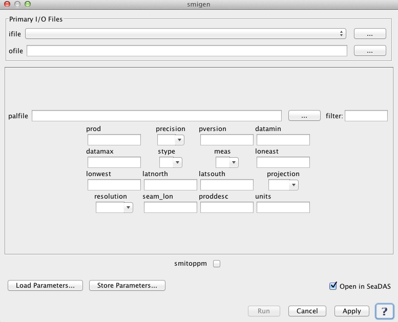
SeaDAS-OCSSW -> smigen
smigen reads in a Level-3 space-binned or time-binned file and generates a Standard Mapped Image (SMI) HDF product containing one of 5 possible statistical measures. SMI products are image representations of binned data products.
 |
| UI Element Name | Type | Description | Required/Optional | Default Value |
| ifile | text | Input bin filename | Required | |
| ofile | text | Output map filename | Required | |
| prod | text | Product name | Required | |
| precision | text | Output map precision: 'B' (default), 'I', 'F' | Optional | |
| palfile | text | Palette filename | optional | default palette file |
| pversion | text | Processing version | Optional | |
| datamin | float | Minimum value for data scaling | Optional | product specific |
| datamax | float | Maximum value for data scaling | Optional | product specific |
| stype | int | Scaling type:
         1: linear
         2: log
|
Optional | product specific |
| meas | int | Measurement to map:
         1: mean
         2: var
         3: stdev
         4: pixels
         5: scenes
|
Optional | 1 |
| loneast | float | Easternmost longitude used for output | Optional | +180 |
| lonwest | float | Westernmost longitude used for output | Optional | -180 |
| latnorth | float | Northernmost latitude used for output | Optional | +90 |
| latsouth | float | Southernmost latitude used for output | Optional | -90 |
| projection | text | Output projection type:
         SIN
         RECT
|
Optional | RECT |
| resolution | text | Output resolution:
         36km
         9km
         4km
         2km
         1km
         1 deg (one deg)
         10 deg (0.1 deg)
|
Optional | 9km |
| seam_lon | float | Longitude of Left Edge of Map | Optional | -180 |
| proddesc | text | Product Description | Optional | |
| units | text | Product Units | Optional |
| UI Element Name | Type | Description |
| Browser Button | Button | Selects infile/ofile |
| Load Parameters ... | Button | Reads in previously saved parameters and populates the fields in GUI. |
| Store Parameters ... | Button | Saves the current arguments in GUI in a file. |
| Run | Button | Executes the smigen command with arguments provided in the UI. |
| Cancel | Button | Closes current processor GUI. |
| Apply | Button | Makes current arguments effective. |
| Open in SeaDAS | Checkbox | If selected, the ofile will be added to the open products list right after its generation. |
| ? | Button | Displays the help content of the current command. |
Usage: smigen ifile ofile prod-name
   par        = parameter filename
   ifile      = input bin filename
   ofile      = output map filename
   oformat    = output format: 1 (HDF4 [default]), 2 (netCDF4), 3 (HDF5)
   deflate    = apply internal compression for netCDF output
   prod       = product name
   precision  = output map precision: 'B' (default), 'I', 'F'
   palfile    = palette filename
   pversion   = processing version (default is Unspecified)
   datamin    = minumum value for data scaling (default is prod-specific)
   datamax    = maximum value for data scaling (default is prod-specific)
   stype      = scaling type,1=LINEAR,2=LOG (default is prod-specific)
   meas       = measurement to map, 1=mean, 2=var, 3=stdev, 4=pixels, 5=scenes (default=1)
   loneast    = Easternmost longitude (default=+180)
   lonwest    = Westernmost longitude (default=-180)
   latnorth   = Northernmost latitude (default=+90)
   latsouth   = Southernmost latitude (default=-90)
   projection = SIN | RECT (default=RECT)
   resolution = 36km | 18km | 9km | 4km | 2km | 1km | hkm | qkm
                1deg (one deg) | hdeg (0.5 deg) | qdeg (0.25 deg)
                10deg (0.1 deg) |udeg-#.# (#.# deg)| ukm-#.# (#.# km) (default=9km)
   seam_lon   = Longitude of Left Edge of Map (default=-180)
   proddesc   = Product Description
   units      = Product Units