
| modis_L1B | |
Creates a MODIS Level 1B file from an input Level 1A file.
Location
Details
Command Line Usage
SeaDAS-OCSSW -> modis_L1B
modis_L1B creates a MODIS Level 1B file from an input Level 1A file.
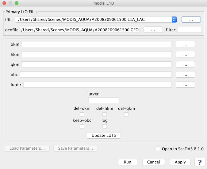 |
| UI Element Name | Type | Description | Required/Optional | Default Value |
| ifile | ifile | MODIS_L1A file name | Required | |
| geofile | ifile | L1A GEO file name | Optional | if GEOFILE is not provided, assumed to be basename of L1AFILE + '.GEO' |
| okm | ofile | Output MODIS L1B 1KM HDF filename | Optional | Derived from the ifile |
| hkm | ofile | Output MODIS L1B HKM HDF filename | Optional | Derived from the ifile |
| qkm | ofile | Output MODIS L1B QKM HDF filename | Optional | Derived from the ifile |
| obc | ofile | Output MODIS L1B OBC HDF filename | Optional | Derived from the ifile |
| lutver | string | L1B LUT version number | Optional | |
| lutdir | string | Path of directory containing LUT files | Optional | |
| del-okm | boolean | Delete 1km resolution L1B file | Optional | false |
| del-hkm | boolean | Delete 500m resolution L1B file | Optional | false |
| del-qkm | boolean | Delete 250m resolution L1B file | Optional | false |
| keep_obc | boolean | Save onboard calibration file | Optional | false |
| log | boolean | Save processing log file(s) | Optional | false |
| UI Element Name | Type | Description |
| Browser Button | Button | Selects ifile/ofile |
| Load Parameters ... | Button | Reads in previously saved parameters and populates the fields in GUI. |
| Store Parameters ... | Button | Saves the current arguments in GUI in a file. |
| Run | Button | Executes the modis_L1B command with arguments provided in the UI. |
| Cancel | Button | Closes current processor GUI. |
| Apply | Button | Makes current arguments effective. |
| Open in SeaDAS | Checkbox | If selected, the ofile will be added to the open products list right after its generation. |
| ? | Button | Displays the help content of the current command. |
    Usage:
        modis_L1B [OPTIONS] L1AFILE [GEOFILE]
            if GEOFILE is not provided, assumed to be basename of L1AFILE + '.GEO'
                or
        modis_L1B --parfile=parameter_file [OPTIONS]


    Options:
      --version             show program's version number and exit
      -h, --help            show this help message and exit
      -p PARFILE, --parfile=PARFILE
                            Parameter file containing program inputs
      -o 1KMFILE, --okm=1KMFILE
                            Output MODIS L1B 1KM HDF filename
      -k HKMFILE, --hkm=HKMFILE
                            Output MODIS L1B HKM HDF filename
      -q QKMFILE, --qkm=QKMFILE
                            Output MODIS L1B QKM HDF filename
      -c OBCFILE, --obc=OBCFILE
                            Output MODIS L1B OBC HDF filename
      -l LUTVER, --lutver=LUTVER
                            L1B LUT version number
      -d LUTDIR, --lutdir=LUTDIR
                            Path of directory containing LUT files
      -x, --del-okm         Delete 1km  resolution L1B file
      -y, --del-hkm         Delete 500m resolution L1B file
      -z, --del-qkm         Delete 250m resolution L1B file
      --keep-obc            Save onboard calibration file
      -v, --verbose         print status messages
      --log                 Save processing log file(s)