
| l1mapgen | |
Creates a Level 1 mapped image (pseudo true color - RGB) image
Location
Details
Command Line Usage
SeaDAS-OCSSW -> l1mapgen
l1mapgen creates a Level 1 mapped image.
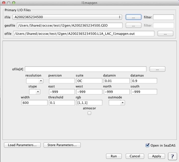 |
| UI Element Name | Type | Description | Required/Optional | Default Value |
| ifile | ifile | Input Level 1 data product. | Required | |
| geofile | ifile | input L1 geolocation file name | Conditional - MODIS only | |
| ofile | ofile | Output image filename for generated map. | Required | |
| resolution | int | processing resolution
       -1: standard ocean 1km processing
     1000: 1km resolution including aggregated 250 and 500m land bands
      500: 500m resolution including aggregated 250 land bands and replication for lower resolution bands
      250: 250m resolution with replication for lower resolution bands
|
Conditional - Required for processing MODIS products | -1 |
| pversion | string | processing version string | Optional | Unspecified |
| suite | sring | product suite string for loading suite-specific defaults | Optional | OC |
| datamin | float | minimum reflectance for scaling | Optional | 0.01 |
| datamax | float | maximum reflectance for scaling | Optional | 0.9 |
| stype | int | scaling type:
        0: log
        1: linear
|
Optional | 0 |
| east | float | east boundary | Optional | -999 |
| west | float | west bounday | Optional | -999 |
| north | float | north boundary | Optional | -999 |
| south | float | south bounday | Optional | -999 |
| width | int | width of output image | Optional | 600 |
| threshold | float | threshold for the number of good pixels before an image is produced | Optional | 0.1 |
| rgb | int | bands to use for red, green and blue | Optional | [1,1,1] |
| oformat | string | defines output format:
        ppm:  output a netPBM PPM file
        png:  output a PNG file
        tiff: output a geoTIFF file
|
Optional | 0 |
| atmocor | boolean | toggle atmospheric correction | Optional | on |
| UI Element Name | Type | Description |
| Browser Button | Button | Selects ifile/ofile |
| Load Parameters ... | Button | Reads in previously saved parameters and populates the fields in GUI. |
| Store Parameters ... | Button | Saves the current arguments in GUI in a file. |
| Run | Button | Executes the l1mapgen command with arguments provided in the UI. |
| Cancel | Button | Closes current processor GUI. |
| Apply | Button | Makes current arguments effective. |
| Open in SeaDAS | Checkbox | If selected, the ofile will be added to the open products list right after its generation. |
| ? | Button | Displays the help content of the current command. |
l1mapgen 9.3.0-seadas-v7.5.2.1 (Dec  3 2018 15:37:25)
Usage: l1mapgen argument-list

  The argument-list is a set of keyword=value pairs. The arguments can
  be specified on the commandline, or put into a parameter file, or the
  two methods can be used together, with commandline over-riding.

  return value: 0=OK, 1=error, 110=north,south,east,west does not intersect
  file data.

The list of valid keywords follows:

   help (boolean) (alias=h) (default=false) = print usage information
   version (boolean) (default=false) = print the version
        information
   dump_options (boolean) (default=false) = print
        information about each option
   dump_options_paramfile (ofile) = print
        information about each option to paramfile
   dump_options_xmlfile (ofile) = print
        information about each option to XML file
   par (ifile) = input parameter file
   pversion (string) (default=Unspecified) = processing version string
   suite (string) (default=OC) = product suite string for loading
        suite-specific defaults
   ifile (ifile) (alias=ifile1) = input L1 file name
   geofile (ifile) = input L1 geolocation file name (MODIS/VIIRS only)
   resolution (int) (default=-1) = processing resolution (MODIS only)
       -1: standard ocean 1km processing
     1000: 1km resolution including aggregated 250 and 500m land bands
      500: 500m resolution including aggregated 250 land bands and
           replication for lower resolution bands
      250: 250m resolution with replication for lower resolution bands
   ofile (ofile) (alias=ofile1) (default=output) = output file name
   oformat (string) (default=ppm) = output file format
        ppm:  output a netPBM PPM file
        png:  output a PNG file
        tiff: output a geoTIFF file
   north (float) (default=-999) = north boundary
   south (float) (default=-999) = south boundary
   east (float) (default=-999) = east boundary
   west (float) (default=-999) = west boundary
   width (int) (default=600) = width of output image
   threshold (float) (default=0.1) = threshold for the number of good pixels
        before an image is produced
   rgb (int) (default=[1,1,1]) = bands to use for red, green and blue
   atmocor (boolean) (default=on) = toggle atmospheric correction
   datamin (float) (default=0.01) = minimum reflectance for scaling
   datamax (float) (default=0.9) = maximum reflectance for scaling
   stype (int) (default=0) = scaling type
        0: log
        1: linear

This program produces a PPM-formatted output image rendered in a Plate Carree
projection.

The default band combination produces a "true-color" image. Other combinations
may be chosen with the "rgb=" option.  The expected argument to this option is
a comma separated string of wavelengths that specifies the desired bands in
red-green-blue order.  For example, to produce a false color SeaWiFS output
image using 865, 670 and 555 nm as the red, green, and blue values
respectively, the option would be specified as "rgb=865,670,555".

   cirrus_opt (boolean) (default=false) = cirrus cloud reflectance correction option
   atrem_opt (int) (default=0) = ATREM gaseous transmittance bitmask selector
        0: H2O only
        1: Ozone
        2: CO2
        4: NO2
        8: CO
       16: CH4
       32: O2
       64: N2O
   atrem_full (int) (default=0) = ATREM gaseous transmittance calculation option
        0: Calculate transmittance using k-distribution method (fast)
        1: Calculate transmittance using full method (slow)
   atrem_geom (int) (default=0) = ATREM gaseous transmittance geometry option
        0: Only recalculate geometry when error threshold reached (fast)
        1: Recalculate geometry every pixel (slow)
   atrem_model (int) (default=0) = ATREM gaseous transmittance Atm. model selection
        0: Use pixel's latitude and date to determine model
        1: tropical
        2: mid latitude summer
        3: mid latitude winter
        4: subarctic summer
        5: subarctic winter
        6: US standard 1962
   atrem_splitpaths (int) (default=0) = ATREM gaseous transmittance split paths between solar and sensor (turns atrem_full on)
        0: Calculates transmittance over total path length (default)
        1: Calculates transmittance over separate solar and sensor paths (slow)