Pixel Geo-Coding
The Pixel Geo-Coding can be used if the user has two bands filled with accurate latitude and longitude values
for each pixel.
For example the FSG and FRG products have corrected latitude ("corr_lat") and longitude ("corr_lon") bands.
These bands can be used to replace the current geo-coding associated with the product.
NOTE:
For information on how to enable the pixel geo-coding on import for MERIS FRG/FSG data products, please
see the Envisat help page.
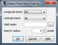
Attach Pixel Geo-Coding
-
Longitude Band
The band which keeps the longitude values for each pixel.
-
Latitude Band
The band which keeps the latitude values for each pixel.
-
Valid Mask
This mask is used by the search algorithm when trying to find the pixel position to a given lat/lon.
Only pixels which meet the expression are included in the search.
-
Search Radius
This value is used by the search algorithm when trying to find the pixel position to a given lat/lon.
A higher value means that the area to search for the proper pixel position is greater and the risk not to
find the searched value is smaller. The greater the value is the longer takes the search.
Detach Pixel Geo-Coding
Just detaches the current pixel geo-coding and restores the previous geo-coding.