
| l3mapgen | |
Creates a Level 3 mapped image.
Takes a product (or products if netCDF output) from an L3 bin file, reprojects the data using Proj.4 and writes a mapped file in the requested output format.
OCSSW -> l3mapgen
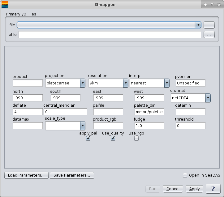 |
| UI Element Name | Type | Description | Required/Optional | Default Value |
| ifile | ifile | Input Level 3 bin file name. | Required | |
| ofile | ofile | Output filename for generated level 3 image file. | Required | |
| product | string | product(s) to map | Required | |
| projection | string | One of the following predefined (proj4) projections may be selected:
     albersconic: "+proj=aea +lon_0={central_meridian}"
     ease2: "+proj=cea +lat_ts=30.0 +lon_0={central_meridian}"
     lambertconformal: "+proj=lcc +lon_0={central_meridian}"
     mercator: "+proj=merc +lon_0={central_meridian}"
     mollweide: "+proj=moll +lon_0={central_meridian}"
     platecaree:"+proj=eqc +lon_0={central_meridian}"
     raw: raw dump of the bin file
     smi: "+proj=eqc +lon_0={central_meridian}"

     Proj4 strings can also be directly entered.
     (See below for a listing of common proj4 formatted strings.)
|
Optional | platecarree |
| resolution | string | size of the output pixel in meters or SMI dimensions:
         90km: 432 x 216 image for full globe
         36km: 1080 x 540
         18km: 2160 x 1080
         9km: 4320 x 2160
         4km: 8640 x 4320
         2km: 17280 x 8640
         1km: 34560 x 17280
         hkm: 69120 x 34560
         qkm: 138240 x 69120
         smi: 4096 x 2048
         smi4: 8192 x 4096
         land: 8640 x 4320
         #.#:  width of a pixel in meters
         #.#km:  width of a pixel in kilometers
         #.#deg:  width of a pixel in degrees
|
Optional | 9km |
| interp | string | interpolation method:
     nearest: Nearest Neighbor
     bin:     bin all of the pixels that intersect the
                area of the output pixel
     area:    bin weighted by area all of the pixels that
                intersect the area of the output pixel
|
Optional | nearest |
| pversion | string | Processing version string | Optional | Unspecified |
| north | float | Northern most Latitude | Optional | -999 |
| south | float | Southern most Latitude | Optional | -999 |
| east | float | Eastern most Longitude | Optional | -999 |
| west | float | Western most Longitude | Optional | -999 |
| oformat | string | format of the output file :
                 netCDF:  netCDF file, can contain more than one product
                 hdf4:    HDF4 file (old SMI format)
                 png:     PNG image file
                 ppm:     PPM image file
                 geoTIFF: TIFF file with georeference tags
|
Optional | netCDF4 |
| deflate | int | deflation level | Optional | 4 |
| central_meridian | float | central meridian for projection in deg east. Only used for convenience projections and assumes whole earthe from east to west. |
Optional | 0 |
| palfile | ifile | palette file name | Optional | the palette is chosen using the product.xml file |
| palette_dir | ifile | palette directory | Optional | $OCDATAROOT/common/palette |
| datamin | float | minimum value for data scaling | Optional | default from product.xml |
| datamax | float | maximum value for data scaling | Optional | default from product.xml |
| scale_type | string | data scaling type:
        linear:   linear scaling
        log:      logarithmic scaling
        arctan:   arc tangent scaling
|
Optional | default from product.xml |
| Product_rgb | string | Three products to use for RGB. Default is sensor-specific | Optional | rhos_670,rhos_555,rhos_412 |
| fudge | float | fudge factor used to modify size of L3 pixels | Optional | 1.0 |
| threshold | float | minimum percentage of filled pixels before an image is generated | Optional | 0 |
| apply_pal | boolean | apply color palette:
            yes: color image
            no: grayscale image
|
Optional | yes |
| use_quality | boolean | should we do quality factor processing | Optional | yes |
| use_rgb | boolean | should we use product_rgb to make a pseudo-true color image | Optional | no |
| UI Element Name | Type | Description |
| Browser Button | Button | Selects infile/ofile |
| Load Parameters ... | Button | Reads in previously saved parameters and populates the fields in GUI. |
| Save Parameters ... | Button | Saves the current arguments in GUI in a file. |
| Run | Button | Executes the l2mapgen command with arguments provided in the UI. |
| Cancel | Button | Closes current processor GUI. |
| Apply | Button | Makes current arguments effective. |
| Open in SeaDAS | Checkbox | If selected, the ofile will be added to the open products list right after its generation. |
| ? | Button | Displays the help content of the current command. |
l3mapgen 2.1.0-seadas-v7.5.2.1 (Nov 17 2018 15:44:29)
Usage: l3mapgen argument-list

  This program takes a product (or products if netCDF output) from an L3 bin
  or SMI file, reprojects the data using proj.4 and writes a mapped file in
  the requested output format.

  Return values
    0 = All Good
    1 = Error
    110 = No valid data to map

  The argument list is a set of keyword=value pairs.  Arguments can
  be specified on the command line, or put into a parameter file, or the
  two methods can be used together, with command line overriding.

The list of valid keywords follows:

   help (boolean) (alias=h) (default=false) = print usage information
   version (boolean) (default=false) = print the version
        information
   dump_options (boolean) (default=false) = print
        information about each option
   dump_options_paramfile (ofile) = print
        information about each option to paramfile
   dump_options_xmlfile (ofile) = print
        information about each option to XML file
   par (ifile) = input parameter file
   suite (string) = suite for default parameters
   ifile (ifile) = input L3 bin filename

   ofile (ofile) (default=output) = output filename
   oformat (string) (default=netcdf4) = output file format
        netcdf4: netCDF4 file, can contain more than one product
        hdf4:    HDF4 file (old SMI format)
        png:     PNG image file
        ppm:     PPM image file
        tiff:    TIFF file with georeference tags
   ofile2 (ofile) = second output filename
   oformat2 (string) (default=png) = second output file format
        same options as oformat
   deflate (int) (default=4) = netCDF4 deflation level

   product (string) = comma separated list of products.
        Each product can have an optional colon and modifier appended.
        For example, "product=chlor_a,chlor_a:stdev,Kd_490:nobs"
        Available modifiers:
            avg       average value (default)
            stdev     standard deviation
            var       variance
            nobs      number of observations in the bin
            nscenes   number of contributing scenes
            obs_time  average observation time (TAI93)
            bin_num   bin ID number

   resolution (string) (default=9km) = size of output pixel
        in meters or SMI dimensions
        90km: 432 x 216 image for full globe
        36km: 1080 x 540
        18km: 2160 x 1080
         9km: 4320 x 2160
         4km: 8640 x 4320
         2km: 17280 x 8640
         1km: 34560 x 17280
         hkm: 69120 x 34560
         qkm: 138240 x 69120
         smi: 4096 x 2048
        smi4: 8192 x 4096
        land: 8640 x 4320
         #.#:  width of a pixel in meters
       #.#km:  width of a pixel in kilometers
      #.#deg:  width of a pixel in degrees
   width (int) = width of output image in pixels; supercedes resolution parameter.

   projection (string) (default=platecarree) = proj.4 projection string or one
        of the following predefined projections:
        smi:       Standard Mapped image, cylindrical projection,
                   uses central_meridian.  NSEW defaults to whole globe.
                   projection="+proj=eqc +lon_0="
        platecarree: Plate Carree image, cylindrical projection,
                   uses central_meridian.
                   projection="+proj=eqc +lon_0="
        mollweide: Mollweide projection
                   projection="+proj=moll +lon_0="
        lambert:   Lambert conformal conic projection
                   projection="+proj=lcc +lon_0="
        albersconic: Albers Equal Area Conic projection
                   projection="+proj=aea +lon_0="
        mercator:  Mercator cylindrical map projection
                   projection="+proj=merc +lon_0="
        obliquemerc:  Oblique Mercator cylindrical map projection
                   projection="+proj=omerc +gamma=0 +lat_0=
                          +lonc= +alpha=
                          +k_0=1 +x_0=0 +y_0=0"
        ease2:     EASE-Grid 2.0 projection
                   projection="+proj=cea +lat_0=0 +lat_ts=30
                          +ellps=WGS84 +datum=WGS84 +units=m
                          +lon_0="
        stere:     Stereographic projection
                   projection="+proj=stere +lat_0= +lat_ts=
                          +lon_0=
                          +ellps=WGS84 +datum=WGS84 +units=m"
        conus:     USA Contiguous Albers Equal Area Conic USGS version
                   projection="+proj=aea +lat_1=29.5 +lat_2=45.5
                         +lat_0=23.0 +lon_0=-96 +x_0=0 +y_0=0
                         +ellps=GRS80 +datum=NAD83 +units=m"
        raw:       Raw dump of bin file contents.

   projection_alt (string) = proj.4 projection string or one
        of the predefined projections.
   alt_thresh_lat (float) (default=999) = absolute value of latitude for switching projection
        to the projection_alt.
   central_meridian (float) (default=-999) = central meridian for projection in deg east.
        Used only for raw dump and predefined projections as above.
   lat_ts (float) = latitude of true scale for projection in deg north.
        Used only for predefined projections above as required.
   lat_0 (float) = latitude of origin for projection in deg north.
        Used only for predefined projections above as required.
   azimuth (float) = projection rotation angle in deg north.
        Used only for predefined projections above as required.
   north (float) (default=-999) = Northernmost Latitude (default: file north)
   south (float) (default=-999) = Southernmost Latitude (default: file south)
   east (float) (default=-999) = Easternmost Longitude (default: file east)
   west (float) (default=-999) = Westernmost Longitude (default: file west)
   trimNSEW (boolean) (default=yes) = should we trim output
        to match input NSEW range

   interp (string) (default=nearest) = interpolation method:
        nearest: Nearest Neighbor
        bin:     bin all of the pixels that intersect the area of the
                  output pixel
        area:    bin weighted by area of all the pixels that intersect
                  the area of the output pixel

   apply_pal (boolean) (default=yes) = apply color palette:
        yes: color image
         no: grayscale image
   palfile (ifile) = palette filename (default from product.xml)
   datamin (float) = minimum value for scaling (default from product.xml)
   datamax (float) = maximum value for scaling (default from product.xml)
   scale_type (string) = data scaling type (default from product.xml)
        linear:  linear scaling
        log:     logarithmic scaling
        arctan:  arc tangent scaling

   quiet (boolean) (default=false) = stop the status printing
   pversion (string) (default=Unspecified) = processing version string
   use_quality (boolean) (default=yes) = should we do quality factor processing
   quality_product (string) = product to use for quality factor processing
   use_rgb (boolean) (default=no) = should we use product_rgb to make a
        pseudo-true color image
   product_rgb (string) (default=rhos_670,rhos_555,rhos_412) =
        Three products to use for RGB.  Default is sensor-specific.
   fudge (float) (default=1.0) = fudge factor used to modify size of L3 pixels
   threshold (float) (default=0) = minimum percentage of filled pixels before
        an image is generated
   num_cache (int) (default=500) = number of rows to cache in memory.
   mask_land (boolean) (default=no) = set land pixels to pixel value 254
   land (ifile) (default=$OCDATAROOT/common/landmask_GMT15ARC.nc) = land mask file
   full_latlon (boolean) (default=yes) = write full latitude and longitude arrays (except for SMI)