
| l2mapgen | |
Creates a Level 2 mapped image.
Location
Details
Command Line Usage
OCSSW -> l2mapgen
<l2mapgen takes a product from a L2 file, maps it using a Plate Carree cylindrical projection, and produces a gray scale PGM or color PPM file.
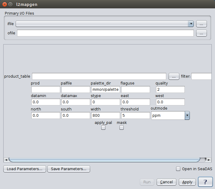 |
| UI Element Name | Type | Description | Required/Optional | Default Value |
| ifile | ifile | Input Level 2 data product. | Required | |
| ofile | ofile | Output filename for generated level 2 image file. | Required | |
| product_table | ifile | product table | Optional | $OCDATAROOT/common/smigen_product_table.dat |
| prod | string | product name | Optional | |
| palfile | ifle | palette file name | Optional | |
| palette_dir | ifile | palette directory | Optional | $OCDATAROOT/common/palette |
| flaguse | string | flags to be masked | Optional | |
| quality | int | minimum allowable quality level for SST. Valid only for SST and only if qual_sst or qual_sst4 SDS exist | Optional | 2 |
| datamin | float | minimum value for data scaling | Optional | 0.0 or see SMI product table |
| datamax | float | maximum value for data scaling | Optional | 0.0 or see SMI product table |
| stype | int | scaling type:
        1: linear
        2: log
|
Optional | 0 or see SMI product table |
| east | float | Map East longitude | Optional | 0.0 or scene(s) Easternmost Longitude |
| west | float | Map West longitude | Optional | 0.0 or scene(s) Westernmost Longitude |
| north | float | Map North longitude | Optional | 0.0 or scene(s) Northernmost Longitude |
| south | float | Map South longitude | Optional | 0.0 or scene(s) Southernmost Longitude |
| width | int | width of the output image | Optional | 800 |
| threshold | float | minimum percentage of the area of interest that must receive valid pixel data before an image is generated | Optional | 5 |
| outmode | string | format of the output file :
                ppm: PPM or PGM image file (alias 1)
                png: PNG color or grayscale image file (alias 2)
                tiff: TIFF color or grayscale geo tiff image file (alias 3)
|
Optional | ppm |
| apply_pal | boolean | apply color palette | Optional | false (gray scale) |
| mask | boolean | apply mask to land, cloud and glint | Optional | no |
| UI Element Name | Type | Description |
| Browser Button | Button | Selects infile/ofile |
| Load Parameters ... | Button | Reads in previously saved parameters and populates the fields in GUI. |
| Store Parameters ... | Button | Saves the current arguments in GUI in a file. |
| Run | Button | Executes the l2mapgen command with arguments provided in the UI. |
| Cancel | Button | Closes current processor GUI. |
| Apply | Button | Makes current arguments effective. |
| Open in SeaDAS | Checkbox | If selected, the ofile will be added to the open products list right after its generation. |
| ? | Button | Displays the help content of the current command. |
l2mapgen 1.0 (Nov 17 2018 15:45:01)
Usage: l2mapgen argument-list

  This program takes a product from a L2 file, maps it using a Plate
  Carree cylindrical projection, and produces a gray scale PGM or
  color PPM file.

  The argument-list is a set of keyword=value pairs. The arguments can
  be specified on the commandline, or put into a parameter file, or the
  two methods can be used together, with commandline over-riding.

The list of valid keywords follows:

   help (boolean) (alias=h) (default=false) = print usage information
   version (boolean) (default=false) = print the version
        information
   dump_options (boolean) (default=false) = print
        information about each option
   dump_options_paramfile (ofile) = print
        information about each option to paramfile
   dump_options_xmlfile (ofile) = print
        information about each option to XML file
   par (ifile) = input parameter file
   ifile (ifile) = input L2 file name or file with a list of files names
   ofile (ofile) = output map filename (NULL=STDOUT)
   prod (string) = product name
   apply_pal (boolean) (default=false) = apply color palette, false = grayscale
   palfile (ifile) (default=default) = palette filename
   palette_dir (ifile) (default=$OCDATAROOT/common/palette) = palette directory
   product_table (ifile) (default=$OCDATAROOT/common/smigen_product_table.dat) = product table
   flaguse (string) = flags to be masked
   quality (int) (default=2) = minimum allowable quality level for SST.  Valid
        only for SST  and only if qual_sst or qual_sst4 SDS exist
   mask (boolean) (default=no) = apply mask to land, cloud and glint (see below)
   datamin (float) (default=0.0) = minimum value for data scaling
        (default see SMI product table)
   datamax (float) (default=0.0) = maximum value for data scaling
        (default see SMI product table)
   stype (int) (default=0) = scaling type (default see SMI product table)
        1: LINEAR
        2: LOG
   east (float) (default=0.0) = Map East longitude
        (default=scene(s) Easternmost Longitude)
   west (float) (default=0.0) = Map West longitude
        (default=scene(s) Westernmost Longitude)
   north (float) (default=0.0) = Map North latitude
        (default=scene(s) Northernmost Longitude)
   south (float) (default=0.0) = Map South latitude
        (default=scene(s) Southernmost Longitude)
   width (int) (default=800) = width of the output image
   threshold (float) (default=5) = minimum percentage of the area of interest
        that must receive valid pixel data before an image is generated
   outmode (string) (default=ppm) = format of the output file
        ppm: PPM or PGM image file (alias 1)
        png: PNG color or grayscale image file (alias 2)
        tiff: TIFF color or grayscale geo tiff image file (alias 3)


   If the "mask" option is set, the output PGM image will be masked for
   flags defined in the flaguse parameter. The "no data" pixel value will
   change from 0 to 255, and pixel values 252, 253, and 254 will represent the
   sunglint, land, and all other (e.g. clouds/ice,hilt,atmfail,navfail,chlfail)
   masks, respectively. NOTE: sunglint is NOT masked by default, but if it is
   added to the flaguse parameter, it will be distinguished in the masking as
   medium gray.  If a palette is applied and the mask option is set, the
   palette values will be modified:
                  Value   R       G       B
                  252     128     128     128
                  253     160     82      45
                  254     255     255     255
                  255     0       0       0

   By default, this program sends its results to standard output as a
   PGM-formatted binary data stream.  Save it to a file via ">" or pipe it
   to your favorite image display program.  The output image is rendered in
   a Plate Carree projection.