
| l1brsgen | |
Creates a Level 1 browse (pseudo true color - RGB) file.
Location
Details
Command Line Usage
Tools -> OCSSW Processing -> l1brsgen
l1brsgen creates small subsetted bitmap samples of the larger datasets. The default SeaWiFS browse product is an 8-bit true color image created from the subsampled and Rayleigh corrected L1A bands. A 24-bit true color image can also be generated.
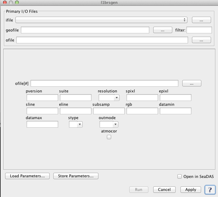 |
| UI Element Name | Type | Description | Required/Optional | Default Value |
| ifile | Text Field | Input Level 1 data product. | Required | |
| geofile | Text Field | input L1 geolocation file name | Conditional - MODIS only | |
| ofile | Text Field | Output filename for generated Level-1B data product. | Required | |
| ofile[#] | Text Field | additional output L2 file name | Optional | |
| pversion | Text Field | processing version string | Optional | Unspecified |
| suite | Text Field | product suite string for loading suite-specific defaults | Optional | OC |
| resolution | int | processing resolution
       -1: standard ocean 1km processing
     1000: 1km resolution including aggregated 250 and 500m land bands
      500: 500m resolution including aggregated 250 land bands and replication for lower resolution bands
      250: 250m resolution with replication for lower resolution bands
|
Conditional - Required for processing MODIS products | -1 |
| spixl | int | start pixel number | Optional | 1 |
| epixl | int | end pixel number | Optional | -1 |
| sline | int | start line number | Optional | 1 |
| eline | int | end line number | Optional | -1 |
| subsamp | int | subsampling interval | Optional | 1 |
| rgb | int | bands to use for red, green and blue | Optional | [1,1,1] |
| atmocor | boolean | toggle atmospheric correction | Optional | on |
| datamin | float | minimum reflectance for scaling | Optional | 0.01 |
| datamax | float | maximum reflectance for scaling | Optional | 0.9 |
| stype | int | scaling type:
        0: log
        1: linear
|
Optional | 0 |
| outmode | int | defines output format:
        0: 8bit HDF
        1: 24bit HDF
        2: PPM
        3: flat binary
        4: PNG
|
Optional | 0 |
| UI Element Name | Type | Description |
| Browser Button | Button | Selects infile/ofile |
| Load Parameters ... | Button | Reads in previously saved parameters and populates the fields in GUI. |
| Store Parameters ... | Button | Saves the current arguments in GUI in a file. |
| Run | Button | Executes the l1brsgen command with arguments provided in the UI. |
| Cancel | Button | Closes current processor GUI. |
| Apply | Button | Makes current arguments effective. |
| Open in SeaDAS | Checkbox | If selected, the ofile will be added to the open products list right after its generation. |
| ? | Button | Displays the help content of the current command. |
Usage: l1brsgen argument-list

  The argument-list is a set of keyword=value pairs. The arguments can
  be specified on the commandline, or put into a parameter file, or the
  two methods can be used together, with commandline over-riding.

The list of valid keywords follows:

   -help (boolean) (alias=-h,--help) (default=false) = print usage information
   -version (boolean) (alias=--version) (default=false) = print the version
        information
   -dump_options (boolean) (alias=--dump_options) (default=false) = print
        information about each option
   -dump_options_paramfile (ofile) (alias=--dump_options_paramfile) = print
        information about each option to paramfile
   -dump_options_xmlfile (ofile) (alias=--dump_options_xmlfile) = print
        information about each option to XML file
   par (ifile) = input parameter file
   pversion (string) (default=Unspecified) = processing version string
   suite (string) (default=OC) = product suite string for loading
        suite-specific defaults
   ifile (ifile) (alias=ifile1) = input L1 file name
   geofile (ifile) = input L1 geolocation file name (MODIS only)
   resolution (int) (default=-1) = processing resolution (MODIS only)
       -1: standard ocean 1km processing
     1000: 1km resolution including aggregated 250 and 500m land bands
      500: 500m resolution including aggregated 250 land bands and
           replication for lower resolution bands
      250: 250m resolution with replication for lower resolution bands
   ofile (ofile) (alias=ofile1) (default=output) = output L2 file #1 name, output vicarious L1B
        for inverse mode
   ofile[#] = additional output L2 file name
   spixl (int) (default=1) = start pixel number
   epixl (int) (default=-1) = end pixel number (-1=the last pixel)
   sline (int) (default=1) = start line number
   eline (int) (default=-1) = end line number (-1=the last line)
   subsamp (int) (default=1) = sub-sampling interval
   rgb (int) (default=[1,1,1]) = bands to use for red, green and blue
   atmocor (boolean) (default=on) = toggle atmospheric correction
   datamin (float) (default=0.01) = minimum reflectance for scaling
   datamax (float) (default=0.9) = maximum reflectance for scaling
   stype (int) (default=0) = scaling type
        0: log
        1: linear
   outmode (int) (default=0) = defines output format
        0: 8bit HDF
        1: 24bit HDF
        2: PPM
        3: flat binary
        4: PNG


The default band combination produces a "true-color" image
Other combinations may be chosen with the "rgb=" option.  The expected
argument to this option is a comma separated string of wavelengths that specifies
the desired bands in red-green-blue order.  For example, to produce a false
color SeaWiFS output image using 865, 670 and 555 nm
as the red, green, and blue values respectively, the option would be specified
as "rgb=865,670,555".